Latitude and longitude are important coordinates that is used extensively to identify a precise location on earth on a two dimensional map. There are 360 imaginary longitudinal lines running from North Pole to South Pole, and there are 180 imaginary latitudinal lines of which 90 are above the equator and 90 below it. With the help of these we can find the location of any place on earth.
But what about space how is positions of stars and planets calculated? How do we tell someone where to look for a particular star?
Suppose we take a globe and blow it so that it extends in all directions across the sky. Then the imaginary lines imprinted on that globe will extend in all directions and form a grid across the sky. This grid lines then becomes the coordinates which are used to identify the location of a celestial object.
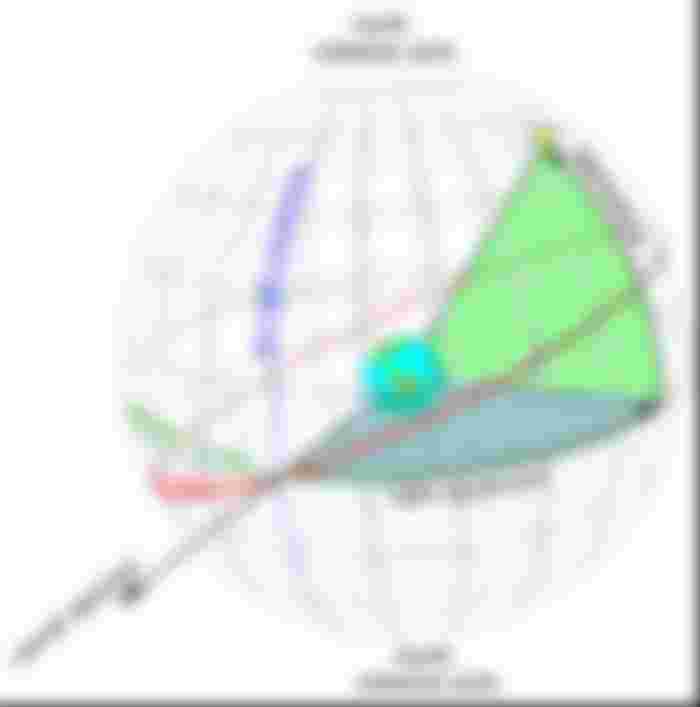

These lines are now called right ascension and declination. Right ascension is just like the longitude lines and declination is like the latitude lines, with two celestial poles, the celestial North Pole and the celestial South Pole and the celestial equator.
But there are some differences here. On earth we take 360 longitudinal lines and write in degree minute and seconds, but for space we take 24 lines as in 24 hours the sun covers a full circle. So in space the right ascension is given in hours minutes and seconds (not degree minutes and seconds). 24 hours is 360 degrees so 1 hour is 15 degrees. Another point is that on earth we have taken the Greenwich line as 0 degree longitude. The 0 degree in the sky is taken as spot where the sun arrives on the first day of the spring, the vernal equinox. It is at Pisces constellation and is taken as the zero hour. Also for space we do not use east or west of 0 degree longitude but only east.
For declination the celestial equator is 0 degree, the celestial North Pole is +90 degrees and celestial South Pole is – 90 degrees.


Unlike earth lat and longs, the celestial coordinates shift because the earth’s axis wobbles. It causes the 0 hour position to shift @50.3 arc seconds (arc means the geometric angle) annually. As the 0 hour shifts it drags the whole coordinate grid. The 0 hour location is marked every 50 years and at present the 2000 location is taken for reference, with the next due in 2050.
This way the Pole star is located at
RA- 2 hr 41 minute and 31 seconds
Dec- +89 deg 15 min and 51 seconds

This way we can calculate the position of all celestial objects and identify in the sky with the help of a celestial map.
So this was a brief introduction to the astronomical grid lines.
As always interesting and informative. My tip today in USDt https://explorer.bitcoin.com/bch/tx/1fe74b429f50680cd74263904f187a33d743812e497442ae1ad21099b7a67182