Last year i visit this historical place. There i found many many historical knowledge. I share to you it below.
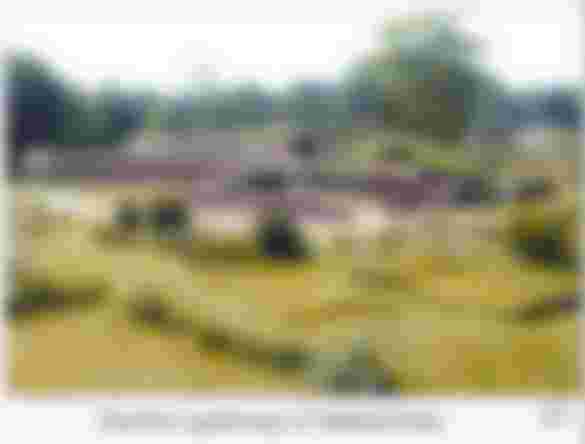
Mahasthan or Mahasthangarh represents the earliest and the largest archaeological site in Bangladesh, consists of the ruins of the ancient city of pundranagara. The site is 13 km north of Bogra town on the Dhaka-Dinajpur highway. The ruins form an oblong plateau measuring 1500m N-S and 1400m E-W and are enclosed on their four sides by rampart walls that rise to an average height of 6m from river level. The highest point within the enclosure at the southeast corner is occupied by the mazar (tomb) of shah sultan mahisawar and by a mosque of the Mughal Emperor farrukh siyar. The latter has been enclosed by a modern mosque, which has been extended recently, a development that precludes the scope of excavation here in future.
The northern, western and southern sides of the fortified city were encircled by a deep moat, traces of which are visible in the former two sides and partly in the latter side. The river Karatoya flows on the eastern side. The moat and the river might have served as a second line of defence of the fort city. Many isolated mounds occur at various places outside the city within a radius of 8 km on the north, south and west, testifying to the existence of suburbs of the ancient provincial capital.
An aerial view of Mahasthan site, Bogra
Many travellers and scholars, notably buchanan, O'Donnell, Westmacott, beveridge and Sir Alexander cunningham visited this site and mentioned it in their reports. But it was Cuningham who identified these ruins as the ancient city of Pundranagara in 1879.
The city was probably founded by the Mauryas, as testified by a fragmentary stone inscription in the Brahmi script mentioning Pudanagala (Pundranagara). It was continuously inhabited for a long span of time.
Eastern gateway of Mahasthan

The first regular excavation was conducted at the site in 1928-29 by the Archaeological Survey of India under the guidance of KN Diksit, and was confined to three mounds locally known as bairagir bhita, govinda bhita and a portion of the eastern rampart, together with the bastion known as munir ghun. Work was then suspended for three decades. It was resumed in the early sixties when the northern rampart area, parasuram palace (Parashuramer Prasad), mazar area, khodar pathar bhita, mankalir kunda mound and other places were excavated. The preliminary report of these excavations was published in 1975. After about two decades excavation was once more resumed in 1988.
Glazed pottery


It then continued for almost every year up to 1991. During this period the work was confined to areas near the mazar and the northern and eastern rampart walls. But the work done in this phase was of negligible scope compared to the vastness of the site. The history and cultural sequence of the site were yet to be established.
The necessity of a thorough investigation for the reconstruction of the early history of the site and the region, and for the understanding of the organisation of the ancient city continued to be felt. Consequently, under an agreement between the governments of Bangladesh and France (1992) a joint venture by Bangladeshi and French archaeologists was undertaken in early 1993. Since then archaeological investigation is being carried out every year in an area close to the middle of the eastern rampart. Excavations have also been conducted earlier by the Department of Archaeology, Bangladesh, in a number of sites outside the fortified city such as Bhasu Vihara,bihar dhap,mangalkot and Godaibari.
Black polished ceramics
Excavation at the city has reached virgin soil at several points. Of these, the recent excavations conducted by the France-Bangladesh mission have revealed 18 building levels. The works carried out at different times from 1929 to the present (including France-Bangladesh expeditions) reveal the following cultural sequence:

Period I represents the pre-Mauryan cultural phase characterised by large quantity of Northern Black Polished Ware (NBPW) of phase B, Rouletted ware, Black and Red Ware (BRW), black slipped ware, grey ware, stool querns, mud-built houses (kitchen) with mud floors, hearths and post-holes. Fine NBPW are more numerous in the lowermost levels; dishes, cups, beakers and bowls are the predominant types. Only a brick-paved floor has been traced in a very restricted area of this level, but no wall associated with this floor has been exposed till now. It appears that the earliest settlement took place over the Pliestocene formation. No precise date for this early settlement could be ascertained. But some radiocarbon dates from the upper level go back to late 4th century BC. This indicates that the 'early settlement' is of pre-Mauryan period. It needs to be ascertained whether this phase belongs to Nanda or pre/proto-historic culture.
Period II is represented by the occurrence of broken tiles (the earliest evidence so far known of this type of roofing), brick-bats used as temper or binding material in the construction of mud walls (also sometimes reused in a domestic context ie, fire place, terracotta ring well),
NBPW pieces


NBPW, common wares of pale red or buff colour, ring stone, bronze mirror, bronze lamp, copper cast coins, terracotta plaques, terracotta animal figurines, semi-precious stone beads, stone mullers and querns. A few calibrated radiocarbon dates (366-162 BC, 371-173 BC) and the cultural materials indicate that this phase represents the Mauryan period.
Period III represents the post-Mauryan (Shunga-Kusana) phase. It is marked by substantial architectural remains of large sized and better-preserved brick built houses, brick-paved floors, post-holes, terracotta ring wells, large quantity of terracotta plaques of Shunga affiliation, beads of semi-precious stones (agate, carnelion, quartz), silver punch marked coins, silver bangle, copper cast coins, antimony rods, terracotta pinnacle, large quantity of common pale red or buff wares (especially dishes, cups and bowls) and grey wares. NBPW of course fabric occurs in less frequency compared to Mauryan level. A few radiocarbon dates give calibrated intervals 197-46 BC, 60 BC-172 AD, 40 BC-122 AD.
Surya
Period IV represents the Kusana-Gupta phase. It is marked by the discovery of substantial amount of Kusana pottery and terracotta figurines with definite stylistic affiliation of the contemporary idiom. The principal pottery types are handled cooking vessels with incised designs, saucers, bowls, sprinklers and lids. Architectural remains are scanty compared to its lower and upper phases. Building materials are represented by small fragments of bricks. Other cultural materials are terracotta beads, bowls, stone and glass beads, glass bangles, terracotta seals and sealings. Gold coins
Gold Coins
Period V represents the Gupta and late-Gupta phase. Radiocarbon data of this phase give calibrated dates between 361 AD and 594 AD. The phase yielded remains of a massive brick structure of a temple called Govinda Bhita, located close to the fort-city, belonging to the late Gupta period, as well as other brick structures - houses, floors, streets - in the city, and huge antiquities, including terracotta plaques of the characteristic style, seals, sealings, beads of terracotta, glass and semi-precious stones, terracotta balls, discs, copper and iron objects, and stamped wares.
Horse riding terracotta figurine
Period VI represents the Pala phase, evidenced by architectural remains of several sites scattered throughout the eastern side of the city, like Khodar Pathar Bhita, Mankalir Kunda, Parasuram's Palace and Bairagir Bhita. This was the most flourishing phase and during this period a large number of Buddhist establishments were erected outside the city.
Beads (Semi precious stone)


Period VII represents the Muslim phase testified by the architectural remains of a 15 domed mosque superimposed over the earlier period remains at Mankalir Kunda, a single domed mosque built by Farrukh Siyar, and other antiquities like Chinese celadon and glazed ware typical of the age.
Beads (glass)


Bairagir Bhita, Khodar Pathar Bhita, Mankalir Kunda Mound, Parasuram’s Palace Mound and Jiat Kunda are some sites inside the city which have yielded archaeological objects of interest. In addition to these sites, excavations in 1988-91 have revealed three gateways of the city, a considerable portion of the northern and eastern rampart, and a temple complex near the mazar area. Out of the three gateways, two are in the northern rampart; one is 5m wide and 5.8m long and is located 442m eastward from the northwest corner of the fort, and the other, situated 6.5m eastward, is 1.6m wide. The gateways were in use in two phases related to the early and later Pala periods. The only gateway in the eastern rampart, located almost in its middle and 100m east of Parasuram’s Palace, is about 5m wide and is thought to have been built in the late Pala period over the remains of an earlier gateway, which has not yet been fully exposed.
Beads (stone)


All the gateway complexes are provided with guardrooms in the inner side, and bastions projecting outside the rampart walls. The temple complex exposed in the mazar area does not reveal a coherent plan. It appears to have been built and rebuilt in five phases, one superimposed over the other, covering the Pala period. The antiquities recovered from the site include a few large size terracotta plaques, toys, balls, ornamental bricks, and earthenwares.
The rampart of the city, built with burnt bricks, belongs to six building periods. The earliest one belonged to the Maurya period, whereas the subsequent ones correspond to Shunga-Kusana, Gupta, early Pala, late Pala, and Sultanate periods. These walls were successively built one above the other.
Silver punchmarked coins
Thus we get a succession of rampart walls as we see the succession of cultural remains inside the city. However, the correlation between the cultural remains of the city of the earliest level and the earliest rampart wall (mud wall?) remains to be established.
Jahajghata (wharf)
Govinda Bhita, lakisndarer madh, Bhasu Vihar, Vihar Dhap, Mangalkot and Godaibadi Dhap are excavated sites located outside the city but within its vicinity. Many more mounds lie scattered in adjacent villages, which are believed to contain cultural remains of the suburbs of the ancient fortified city of Pundranagar
Mahasthangarh is one of the earliest urban archaeological sites so far discovered in Bangladesh. The village Mahasthan in Shibganj thana of Bogra District contains the remains of an ancient city which was called Pundranagara or Paundravardhanapura in the territory of Pundravardhana.... Mahasthan or Mahasthangarh represents the earliest and the largest archaeological site in Bangladesh, consists of the ruins of the ancient city of pundranagara. The site is 13 km north of Bogra town on the Dhaka-Dinajpur highway....
Bangladesh is a country of rich archaeological heritage, especially from the medieval period. The glorious history of Bangladesh reveals that Hinduism and Buddhism flourished during important ruling dynasties like the Mauryans, the Guptas, the Palas, the Chandras, and Deva and Sena kings. Under their royal patronage, numerous Buddhist monasteries were established all over the country.
Mahasthangarh is one of the oldest and the most important archaeological attractions in Bangladesh. ‘Mahasthan’ means ‘great sanctity’ and ‘garh’ means fort. Mahasthangarh is the remains of the ancient city of Pundranagar. It was the capital of the Maurya, Gupta and Sen kingdoms.
This ancient archeological and historical site, established around 2500 BC, is located at Shibganj upazila of Bogra district. It lies on the western bank of Korotoa River, about 13 km north of Bogra city on the Dhaka-Dinajpurpur highway.
It is believed that the rulers of the Maurya dynasty founded the city. It is the earliest evidence of urbanisation in ancient Bengal. A broken limestone slab from the 3rd century BC that bears six lines in ‘Brahmi’ script has been found there with the name ‘Pundranagar’ inscribed on it.
The entire area is surrounded by a fortification wall. The oblong enclosure measures 1,525 metres by 1,370 metres, with an average height of 5 metres. Evidence has been found at the site of successive Hindu, Buddhist and Muslim occupation. The Buddhists were there at least until the 11th century. Their most glorious period was between the 8th and 11th centuries, when the Buddhist Pala emperors of North Bengal ruled.
Beyond the fortified area, there are some other ancient ruins within a semicircle of about 8 km radius. Various mounds and monasteries (bihar) are scattered throughout the vast area outside the fortification wall. Among them, Bairagir Bhita, Govinda Bhita, Khodar Pathar (stone of God) mound, Mankalir Kunda mound, Parasuramer Prashad Mound, Jiyut Kunda (Well of Life), Godaibari Dhap, Noropotir Dhap, Gokul Medh (Lokhindorer Bashor Ghar), and Bhasu Bihar are mentionable.
Inside the fortified enclosure, the highest place in the southeast corner is occupied by the tomb of a Muslim saint, Shah Sultan Balkhi Mahisawar, and a mosque built by Mughal Emperor Farrukh Siyar. The archaeological site is still revered by the Hindus. Every year in mid-April, and once every 12 years in December, thousands of Hindu devotees join a bathing ceremony on the banks of the Korotoa.
There is a museum at the site where a wide variety of antiquities, gold ornaments, coins, terracotta plaques, toys, earthenware and so on unearthed from Mahasthangarh are preserved.
Several scholars and travellers contributed to the discovery and identification of the ruins at Mahasthangarh. Among them, the contribution of Francis Buchanan Hamilton, CJ O’Donnell, EV Westmacott, Beveridge and Alexander Cunningham are mentionable. Hamilton was the first to locate Mahasthangarh in 1808. Cunningham, who visited the site in 1879, was the first to identify the place as the capital of Pundra-bardhan. Chinese traveller Hiuen Tsiang (also known as Xuanzang) came to visit Basu Bihar monastery in this area in 639-645 AD.
The rise of society and civilisation in Mahasthangarh, its prosperity and fall ranges from 3rd Century BC to 15th Century AD. A recent excavation by a France-Bangladesh team unveils 18 construction layers, which is quite a fascinating discovery.
Mahasthangarh is our pride that must be treasured. We must take care to preserve this invaluable heritage of our country. In a 2010 report titled ‘Saving Our Vanishing Heritage’, Global Heritage Fund identified Mahasthangarh as one of 12 worldwide sites most “on the verge” of irreparable loss and damage, citing insufficient management (poor water drainage in particular) and looting as primary causes.